Add a blog post title
sites • July 1, 2019
This is a subtitle for your new post
The body content of your post goes here. To edit this text, click on it and delete this default text and start typing your own or paste your own from a different source.
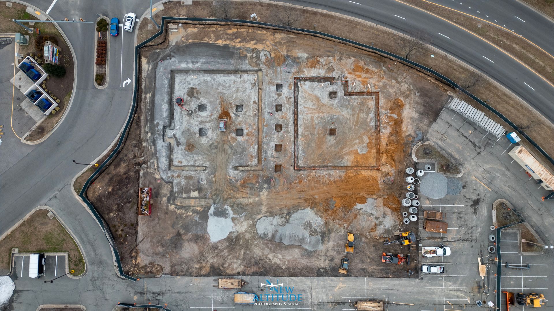
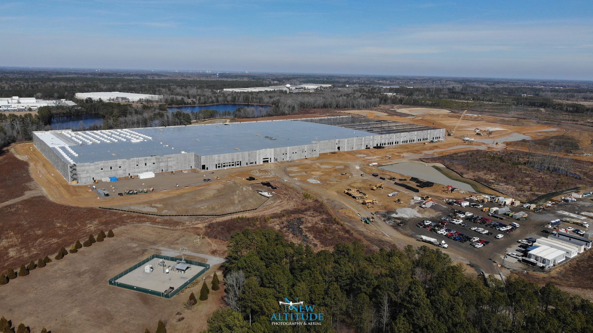
Construction projects across Richmond, VA, Mechanicsville, and Hanover County are moving faster than ever. Builders and developers need reliable ways to track progress, communicate with stakeholders, and document each phase of construction. That’s why many companies are turning to construction drone photography in Richmond, VA as a smarter and more efficient solution. At New Altitude Photography & Aerial , we provide professional construction drone photography and aerial progress documentation throughout Richmond and Central Virginia , helping contractors and project managers stay informed and organized from site preparation to final completion. Drone photography provides a clear overhead perspective that traditional ground photography simply cannot match. Why Construction Companies Use Drone Photography Construction drone photography has become an essential tool for modern project management. Aerial imagery provides a complete view of the job site, allowing builders to monitor progress without needing to be physically present. Professional drone construction photography in Richmond, VA helps companies: Monitor project progress Document completed work Share updates with clients Improve communication Reduce site visits Track timelines Identify potential issues early Instead of relying only on ground-level photos, drone imagery gives project managers a full understanding of how the site is developing. This makes aerial documentation one of the most valuable tools available for construction companies today. Monthly Drone Progress Reports Keep Projects Organized Many builders in Richmond and Mechanicsville schedule regular drone flights to document project progress. Monthly or bi-weekly aerial updates provide: Consistent viewpoints over time Visual progress comparisons Reliable project records Easy sharing with stakeholders Documentation for investors Regular drone progress photography creates a timeline that shows exactly how a project developed from start to finish. These visual records are valuable long after the project is completed and can be used for marketing future projects. Aerial Views Improve Communication Construction projects often involve multiple stakeholders including: Owners Investors Developers Project managers Engineers Contractors Drone photography makes communication easier by providing clear visual updates that everyone can understand. Instead of long written updates, aerial images quickly show: Current progress Completed work Equipment placement Material staging Overall site layout This helps eliminate confusion and keeps projects moving forward efficiently. Document Every Phase of Construction Professional construction drone photography in Richmond, VA captures every stage of development including: Site Preparation Drone imagery documents land clearing, grading, and early site work. Foundation Work Aerial photos provide clear views of footings and slab preparation. Structural Framing Progress becomes more visible as buildings take shape. Roofing and Exterior Work Drone photography captures areas that are difficult to see from the ground. Final Completion Completed projects can be documented for marketing and portfolio use. Capturing each stage creates a complete visual history of the project. Reduce Time Spent Visiting Job Sites Project managers often oversee multiple job sites across Richmond and Hanover County. Traveling between sites takes valuable time. Drone photography allows project managers to: Check progress remotely Reduce unnecessary site visits Monitor multiple projects Save travel time Improve efficiency Instead of driving to every site weekly, aerial updates provide reliable visual information quickly. Improve Marketing for Future Projects Completed construction projects make excellent marketing material. High-quality drone photography allows builders to showcase: Finished buildings Site layout Professional workmanship Project scale Before-and-after comparisons These visuals can be used on: Company websites Social media Google Business Profiles Project proposals Marketing brochures Professional aerial imagery helps contractors stand out when bidding on future work. Why Choose New Altitude Photography & Aerial New Altitude Photography & Aerial provides reliable construction drone photography in Richmond, Mechanicsville, and Hanover County. We work with contractors and developers to provide consistent aerial updates and professional results. Our services include: ✔ Scheduled progress flights ✔ High-resolution aerial photography ✔ Professional drone video ✔ Consistent flight paths ✔ Fast turnaround times We understand construction timelines and work to provide reliable scheduling that keeps your project documentation on track. FAA Certified and Insured Drone Operations Professional drone operations require proper licensing and insurance. New Altitude Photography & Aerial provides: FAA Part 107 Certified drone pilots Fully insured drone operations Professional-grade equipment Safe and compliant flights Working with a certified drone provider ensures your project is handled safely and professionally. Construction Drone Services in Richmond and Surrounding Areas We proudly provide construction drone photography services throughout Central Virginia, including: 📍 Richmond 📍 Mechanicsville 📍 Hanover County 📍 Ashland 📍 Glen Allen 📍 Henrico County We work with commercial builders, residential developers, and contractors of all sizes. Schedule Construction Drone Photography in Richmond, VA If you're managing a project and need reliable construction drone photography in Richmond, VA, New Altitude Photography & Aerial provides consistent aerial documentation and professional service. Regular aerial updates help keep projects organized, improve communication, and create valuable records of your work. Contact New Altitude Photography & Aerial 📞 Call or Text: 804-944-3853 🌐 www.nadroneimages.com Schedule your next construction drone flight today and keep your project documented from start to finish. 🚁📸
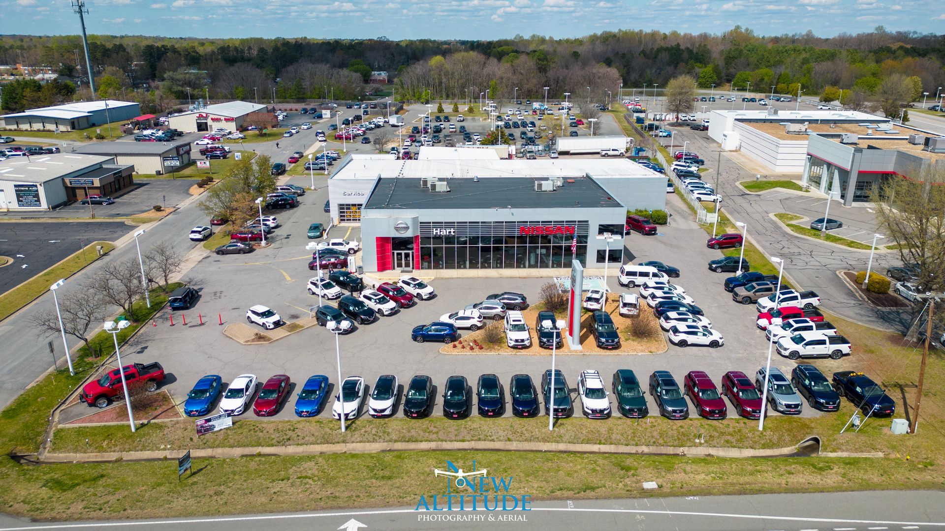
If you're searching for professional drone photography in Mechanicsville, VA, you're not alone. More businesses, contractors, real estate professionals, and property owners across Mechanicsville, Richmond, and Hanover County are turning to aerial photography to showcase their properties and projects in a way traditional photos simply cannot. At New Altitude Photography & Aerial , we provide high-quality aerial photography and drone video services in Mechanicsville and throughout Central Virginia , helping businesses stand out online and make a stronger first impression. Drone photography provides a unique perspective that highlights property size, layout, and surroundings while creating professional marketing content that attracts attention and builds trust. Why Drone Photography is Growing in Mechanicsville, VA Mechanicsville and Hanover County continue to grow with new construction, expanding neighborhoods, and thriving local businesses. With increased competition, businesses need better ways to stand out online. Professional aerial photography in Mechanicsville, VA allows companies to present their locations and projects with a modern, professional look that customers expect. Drone photography helps: Show property size and layout Highlight business locations Capture construction progress Improve marketing materials Increase online visibility Build credibility with customers Many customers now search online before making decisions, and strong visuals often determine which business they contact first. How Drone Photography Helps Local Businesses Contractors and Construction Companies Contractors throughout Mechanicsville and Richmond use drone photography to document projects and showcase completed work. Aerial images allow builders to: Track construction progress Share updates with clients Market completed projects Document site conditions Create before-and-after comparisons Consistent aerial updates also provide a permanent record of each stage of construction. Construction companies benefit from drone photography because it saves time while improving communication with clients and project managers. Commercial Properties Commercial property owners and developers use drone photography in Mechanicsville, VA to showcase their buildings and sites from a complete perspective. Aerial imagery helps highlight: Parking areas Access points Building size Nearby roads Surrounding businesses Property layout These details are especially important for investors and potential tenants evaluating a property. Real Estate Listings Real estate professionals rely on aerial photography to make listings stand out. Drone photos help buyers understand: Property boundaries Lot size Surrounding neighborhoods Nearby amenities Driveway access Land features Properties with aerial photography often generate more interest because buyers can see the full picture before visiting in person. Improve Your Google Business Profile With Aerial Photos One of the biggest benefits of drone photography in Mechanicsville is improved online visibility. Professional aerial images help businesses: Stand out in Google search results Improve customer trust Increase profile views Get more calls and inquiries Look more established online Businesses with professional photos often receive more engagement than those using basic smartphone images. High-quality aerial photos give customers confidence that they are working with a professional company. Why Work With a Local Drone Company Choosing a local drone company in Mechanicsville, VA provides several advantages. New Altitude Photography & Aerial understands the local area and works regularly throughout: Mechanicsville Richmond Hanover County Glen Allen Ashland Central Virginia Working with a local provider means: Faster scheduling Reliable service Knowledge of local airspace Familiarity with job sites Consistent availability Local experience makes a difference when planning safe and efficient drone flights. FAA Certified and Fully Insured Drone Services Professional drone photography requires more than just flying a drone. Safety, compliance, and experience matter. New Altitude Photography & Aerial provides: FAA Part 107 Certified drone pilots Fully insured operations Professional-grade equipment High-resolution images and video Reliable scheduling Working with a licensed drone operator ensures your project is completed safely and professionally. Industries That Benefit From Drone Photography Drone photography is useful for many industries across Mechanicsville and Richmond , including: Construction Job site progress Marketing completed projects Project documentation Real Estate Residential listings Commercial properties Development parcels Contractors Landscaping projects Grading projects Hardscaping projects Property improvements Businesses Storefront visibility Facility overviews Marketing content If your business has a physical location or outdoor projects, aerial photography can provide valuable marketing content. What to Expect During a Drone Photography Project Working with New Altitude Photography & Aerial is simple and efficient. Step 1 – Scheduling We coordinate a convenient time based on weather and lighting conditions. Step 2 – Flight Planning Each project is carefully planned to capture the best angles and perspectives. Step 3 – Drone Flight Professional aerial photos and videos are captured safely and efficiently. Step 4 – Editing Images are professionally edited for clarity and quality. Step 5 – Delivery Final files are delivered digitally for easy use on websites and marketing materials. Most projects can be completed quickly with minimal disruption to your business or job site. Schedule Drone Photography in Mechanicsville, VA If you're looking for professional drone photography in Mechanicsville, VA, New Altitude Photography & Aerial provides reliable service and high-quality results. We proudly serve: 📍 Mechanicsville 📍 Richmond 📍 Hanover County 📍 Central Virginia Whether you need construction drone photography, commercial aerial imagery, or real estate drone photos, we can help you capture your project from the best perspective. Contact New Altitude Photography & Aerial Today 📞 Call or Text: 804-944-3853 🌐 Website: www.nadroneimages.com Schedule your aerial photography project today and see your property from a new altitude. 🚁📸
Construction Progress Reporting In Richmond & Mechanicsville Va